FAQ
Below you'll find answers to the most frequently asked questions. We continuously update these based on questions received.
Questions about the user account
Why is user creation required for using the API's?
User registration is not needed nor possible any longer. Read more under Authentication.
Questions about the API's
How do I use the API?
You can access the API specification as well as Request & Response examples and information on data sources by choosing the appropriate data type in the menu on the left side of the screen.
Where do I find the API documentation?
You are able to access the current API documentation by choosing the appropriate data type on the Data page.
Can I call the API from all applications and platforms?
DMI’s API's are REST based and thus platform- and language agnostic. Furthermore, as DMI's data are classified as High Value Data, the API's follow OGC-standards.
How do I query several parameters and/or stations?
Unfortunately, it is only possible to query serveral parameters, when using our forecast-EDR-API.
It is not possible to include multiple parameters in a single query in our metObs, oceanObs, climateData, or lightningData API’s. If you want to query more than one parameter in these API’s, you need to query each parameter separately or query all parameters and then filter out the parameters you don’t want afterwards.
If you want to query multiple stations, you can use a bbox query to do so, if the stations of interest are within the same geographical area. Another option is to query each station separately, or you can query all stations and filter out the stations you don’t want afterwards.
How do I receive information about new versions of the API's?
By registering as a user you will automatically receive a notification at the registered email address, when a new version of the API is released.
Are there any restrictions on the number of requests, I can perform against the APIs?
There is a fair use limit to allow only 500 requests per 5 seconds. If more requests are received a HTTP 429 error is returned. We continuously monitor the use of the API’s and will adjust this limit to ensure, that all users have fair access.
We also recommend using the download functionality, if you want to download large quantities of data. The download functionality is available for the following services: metObs, oceanObs, climateData, and lightningData.
What is the uptime of the API?
We strive to provide an uptime of the API’s around 99.9 %.
Downtime is not expected, but in case of planned downtime, it will be announced under API Status & Contact.
Questions about the data
What type of data can I get through the API's?
The following data is available through the current API's:
- Meteorological Observations Data
- Oceanographic Observations Data
- Lightning Data
- Climate Data
- Radar Data
- Forecast Data (applies to both the Forecast Data STAC-API and Forecast Data EDR API)
How may I use data?
You can freely use DMI’s data for any purpose including further processing and distribution. Be aware, that you may not make changes to the actual data retrieved from DMI. Please read the Terms of Use for further information.
Is there any limitation to the use of data?
Data retrieved from DMI may not be changed. DMI reserves the right to block or adjust the bandwidth for individual users, if these strain DMI’s API's to a disproportionately wide extent.
How often is data updated?
You can see the update frequency by choosing the appropriate data type on the Data page and then choosing “Parameters”.
Please note that lightning data does not have a specific update frequency, since the data is updated in real time.
How do I retrieve large quantities of data?
If you want to download large quantities of historical data, we recommend that you use download. This lets you download .zip files, each containing historic data for a month or year. Files contain the same data as in the API and are updated hourly.
What format does data come in?
DMI’s open data is retrieved in JSON format (”JavaScript Object Notation”). JSON is a compact file format for the exchange of data. JSON is a text format which is platform- and language agnostic and which can be read by humans as well as machines. The JSON format can easily be converted to other file formats such as .csv or .xml.
All API's return GeoJSON (external site) for query responses and the downloaded files from Radar and Forecast APIs are in HDF5 and GRIB format, respectively.
Are data available in GIS format?
Data retrieved through the API is only available in JSON format, but DMI's open data can easiliy be imported directly into GIS. Please see our guide.
For QGIS there is a plugin called "DMI Open Data", that can be used to easily import data. Please see our guide.
Are data available in CSV/excel?
Data from our OGC API-features services (metObs, oceanObs, lightningdata and climateData) can be imported into excel. Please see our guide.
What does it mean that observation data are not quality controlled?
Observation data have not been subject to quality control nor processed in any way. Errors in measurements may occur. Errors are typically due to malfunction of instruments caused by wear and tear or exposure to weather and in some cases seawater and on rare occasions from vandalism. Wear and tear of the instruments are handled proactively by performing service checks at the stations on a regular basis and changing the instruments within the given time frame. Due to this, you have to be aware of the risk of faulty measurements when using DMI’s observation data.
Can I download data from third parties through the DMI API?
It is possible to download data from third parties through the DMI API, if an agreement exists between the third party and DMI. The owner of the station is marked in the station list of the service.
If you have questions regarding data from third parties, please contact the authority responsible for the specific station or the data derived therefrom.
What if data is missing?
The data retrieved through DMI's Open Data API correlates to the data available to DMI. Sometimes you may experience that some data entries are missing. The root cause of this is typically a malfunctioning measurement instrument, which DMI will repair as soon as possible.
What coordinate datum is used for the location of the stations?
The coordinate datum used for the location of the stations is WGS84.
Why is DMI’s 1x1km grid data not available as open data?
The 1x1 km grid is used as an intermediate basis to construct the spatial resolutions 10x10 km, 20x20 km, municipality data and country data. Under certain weather conditions the 1x1 km grid data can be quite imprecise, but by aggregating it to larger areas the uncertainty is reduced. Furthermore, 3rd party data, which DMI doesn’t have permission to redistribute, can be deducted directly from the 1x1 km grid data.
What if I have questions about the data?
If you have questions regarding data, please contact the authority responsible for the specific station or the data derived therefrom.
You can see the owner of a station by selecting the appropriate data type on the Data page and then choosing “Stations” and then clicking the link for the station list.
What kind of optical flow method do you use for DMI’s radar forecast?
In the radar forecast on dmi.dk we use Gunnar Farnebäck's dense optical flow algorithm as implemented in OpenCV: https://docs.opencv.org/3.4/de/d9e/classcv_1_1FarnebackOpticalFlow.html (external site).
We also use a range of other methods (e.g. Lucas-Kanade optical flow) available in pySTEPS: https://pysteps.readthedocs.io (external site).
Why is radar data in 5 minute intervals on www.dmi.dk when full-range radar scans are only available in ten minute intervals through the open data service?
Radar data on dmi.dk is a special product that only shows the lowest elevation scan which is gathered every 5 minutes. This data is currently not a part of DMI’s open data service.
Why is the geographical location of the DKSS forecast model inaccurate when visualized in certain GIS tools?
Depending on which tool or application used to visualize and process the GRIB file, an error in the geographical placement might occur due to a maximal decimal precision of three in GRIB files. Because of the high resolution of the model, a precision of 4 or 5 decimals is needed in certain geographical areas.
In order to compensate you have to use the eastern and western reach together with the number of grids all of which are written in the header of the GRIB file, to calculate the grid distance in degrees as shown in the following equation:
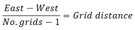
A precision of at least five decimals is recommended when using the above equation.
Now use the calculated grid distance along with the western reach and the number of grids to calculate the accurate eastern reach by using the following equation:

Where can I report errors?
You can report errors by using the contact form at https://www.dmi.dk/kontakt/frie-data/
If you have questions regarding data from third parties, please contact the authority responsible for the station or the data derived therefrom.
If you are experiencing that the API is out of service please check the API status page or contact The Agency for Governmental IT Services (SIT - Statens It).
Call SIT: +45 72 31 00 01


