Weather Model (HARMONIE) for DINI and IG
Description
DMI uses and codevelops the weather model HARMONIE. The weather model produces forecast data for e.g. temperature, dew point temperature, cloud cover, wind, pressure and several others parameters. DMI’s weather model HARMONIE is available in two different versions that cover the geographical areas of Iceland and Greenland (IG) and Denmark, Iceland, Netherlands and Ireland (DINI), respectively. Both versions of the weather model uses a grid resolution of 2 km. DMI’s HARMONIE model runs cycle 43h (https://journals.ametsoc.org/view/journals/mwre/145/5/mwr-d-16-0417.1.xml (external site)) with boundary conditions from the global weather model ECMWF.
The model focuses on events that take place on small scale but can have serious outcomes, e.g. extreme precipitation like cloudburst (convective precipitation) and rapidly changing storm low.
HARMONIE is an abbreviation of Hirlam Aladin Research towards Mesoscale Operational NWP in Europe and is developed through an international collaboration. Hirlam and Aladin are the names of two groups of meteorological institutions in Europe, therefore HARMONIE has a broad European foundation.
DMI’s HARMONIE model also creates start input for DMI’s downstream ocean models (Wave Model WAM and Storm Surge model DKSS).
Number of Runs and Forecast Range
DMI’s HARMONIE model runs every hour on our supercomputer located in Iceland. DMI only collects the deterministic run every third hour (00z, 03z, 06z, 09z, 12z, 15z, 18z and 21z). Every run produces a forecast of the atmospheres 3-dimensional condition for the next days.
The forecast range for HARMONIE varies based on what time the model run begins. In the table below, you can see the forecast range for the different model run times:
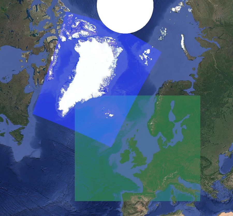
Model areas
HARMONIE has two geographical areas: IG and DINI that cover Iceland/Greenland and Northwestern Europe, respectively.
Types of model output:
The weather model has three types of model output:
- Surface (sf)
- Model levels (ml)
- Pressure levels (pl)
Surface levels (sf)
The surface files consist of a combination of the model’s surface scheme and interpolation from the model layers. The surface files therefore consists of parameters that are defined by the surface (e.g. soil temperature, 2 m temperature, 10 m wind). The surface files also contain parameters that are integrated across layers through the entire atmosphere (e.g. precipitation and cloud cover). It is in the surface level files, that you will find the most common parameters.
Please also see the parameter list.
Model levels (ml)
The first raw output data from the model are model levels. DINI and IG have 90 layers that all describe the atmosphere. The layers are placed close together at the surface and gradually move further apart up through the atmosphere. Close by the earth’s surface the layers follow the surface’s topography. Further up in the atmosphere the layers follow the pressure levels.
Please also see the parameter list.
Pressure levels (pl)
The model levels are recalculated to relevant pressure levels (see pressure levels below) and selected parameters are interpolated to these pressure levels.
The pressure levels are: 1000, 950, 925, 900, 850, 800, 700, 600, 500, 400, 300, 250, 200, 150, 100, and 50hPa.
The calculated parameters are: vertical speed, wind components u and v, temperature, geopotential, relative humidity, geometrical vertical speed, pseudoadiabatic potential temperature, potential vorticity.
Please also see the parameter list.
Coordinate Reference System
The models use a Lambert conformal conic projection (external site). Projection parameters can be shown using the grib_dump (external site) tool, QGIS (external site) or by calling the Forecast EDR service /collections/harmonie_dini_sf/ or /collections/harmonie_ig_sf/ endpoints, which reports the projection in WKT format (included below).
Wind u/v vectors also are also in relation to the lambert projection. If you wish to project wind direction to another coordinate reference system, you also need to rotate the wind accordingly. The Forecast EDR service does this rotation to CRS84 if the parameter crs=crs84 is used.
DINI WKT:
		PROJCRS["DMI HARMONIE DINI lambert projection",
    BASEGEOGCRS["DMI HARMONIE DINI lambert CRS",
        DATUM["DMI HARMONIE DINI lambert datum",
            ELLIPSOID["Sphere",6371229,0,
                LENGTHUNIT["metre",1,
                    ID["EPSG",9001]]]],
        PRIMEM["Greenwich",0,
            ANGLEUNIT["degree",0.0174532925199433,
                ID["EPSG",9122]]]],
    CONVERSION["Lambert Conic Conformal (2SP)",
        METHOD["Lambert Conic Conformal (2SP)",
            ID["EPSG",9802]],
        PARAMETER["Latitude of false origin",55.5,
            ANGLEUNIT["degree",0.0174532925199433],
            ID["EPSG",8821]],
        PARAMETER["Longitude of false origin",-8,
            ANGLEUNIT["degree",0.0174532925199433],
            ID["EPSG",8822]],
        PARAMETER["Latitude of 1st standard parallel",55.5,
            ANGLEUNIT["degree",0.0174532925199433],
            ID["EPSG",8823]],
        PARAMETER["Latitude of 2nd standard parallel",55.5,
            ANGLEUNIT["degree",0.0174532925199433],
            ID["EPSG",8824]],
        PARAMETER["Easting at false origin",0,
            LENGTHUNIT["metre",1],
            ID["EPSG",8826]],
        PARAMETER["Northing at false origin",0,
            LENGTHUNIT["metre",1],
            ID["EPSG",8827]]],
    CS[Cartesian,2],
        AXIS["(E)",east,
            ORDER[1],
            LENGTHUNIT["Metre",1]],
        AXIS["(N)",north,
            ORDER[2],
            LENGTHUNIT["Metre",1]]]
and IG WKT:
		PROJCRS["DMI HARMONIE IG lambert projection",
    BASEGEOGCRS["DMI HARMONIE IG lambert CRS",
        DATUM["DMI HARMONIE IG lambert datum",
            ELLIPSOID["Sphere",6371229,0,
                LENGTHUNIT["metre",1,
                    ID["EPSG",9001]]]],
        PRIMEM["Greenwich",0,
            ANGLEUNIT["degree",0.0174532925199433,
                ID["EPSG",9122]]]],
    CONVERSION["Lambert Conic Conformal (2SP)",
        METHOD["Lambert Conic Conformal (2SP)",
            ID["EPSG",9802]],
        PARAMETER["Latitude of false origin",72.000002,
            ANGLEUNIT["degree",0.0174532925199433],
            ID["EPSG",8821]],
        PARAMETER["Longitude of false origin",-36.000001,
            ANGLEUNIT["degree",0.0174532925199433],
            ID["EPSG",8822]],
        PARAMETER["Latitude of 1st standard parallel",72.000002,
            ANGLEUNIT["degree",0.0174532925199433],
            ID["EPSG",8823]],
        PARAMETER["Latitude of 2nd standard parallel",72.000002,
            ANGLEUNIT["degree",0.0174532925199433],
            ID["EPSG",8824]],
        PARAMETER["Easting at false origin",0,
            LENGTHUNIT["metre",1],
            ID["EPSG",8826]],
        PARAMETER["Northing at false origin",0,
            LENGTHUNIT["metre",1],
            ID["EPSG",8827]]],
    CS[Cartesian,2],
        AXIS["(E)",east,
            ORDER[1],
            LENGTHUNIT["Metre",1]],
        AXIS["(N)",north,
            ORDER[2],
            LENGTHUNIT["Metre",1]]]
Parameters
HARMONIE Denmark, Iceland, Netherlands and Ireland (harmonie_dini_sf)
HARMONIE Iceland and Greenland (harmonie_ig_sf)
HARMONIE Denmark, Iceland, Netherlands and Ireland (harmonie_dini_pl)
HARMONIE Iceland and Greenland (harmonie_ig_pl)
HARMONIE Denmark, Iceland, Netherlands and Ireland (harmonie_dini_ml)
edition number is 2 and gridType is lambert for all grib records in the table below
HARMONIE Iceland and Greenland (harmonie_ig_ml)
Ensemble statistical models
In addition to the regular DINI forecast DMI also runs an Ensemble - a set of model runs with slightly different initial conditions. Each of these model runs (Ensemble members) give a different outcome and from the distribution of these outcomes the statistical model files are derived.
The statistical models are:
- harmonie_dini_eps_means - is the average value of all the ensemble members.
- harmonie_dini_eps_percentiles - is the 0, 10, 25, 50, 75, 90 and 100 percentile values. For percentage value 0 it is the minimum value of all ensemble members. For percentage value 10 the value is such that 10% of the ensemble members are below the value and 90% are above. For the percentage value 50 half the ensemble members are below and half are above this value. For percentage value 100 this the maximal value of all the ensemble members.
- harmonie_dini_eps_probabilities - is the relative number (a number between 0 and 1) of ensemble members being above or below a certain threshold. The threshold is noted in the scaledValueOfLowerLimit and scaledValueOfUpperLimit with value 0 being no threshold. Note that this threshold is not just for the point, it can also be points in near vicinity.
Parameters
HARMONIE Denmark, Iceland, Netherlands and Ireland (harmonie_dini_eps_means)
HARMONIE Denmark, Iceland, Netherlands and Ireland (harmonie_dini_eps_percentiles)
Note, that some of the percentile model parameters have a stepRange parameter which describes a time interval.
The parameters in question are listed below:
- “Total precipitation”, has 1 and 6 hours stepRanges. This means that fx total precipitation after 6 hours will be present in modelfiles after timestep 6 and later .
- “Time integral of total solid precipitation flux” which also have 1 and 6 hour stepRanges
- “Maximum 10 metre wind gust since previous post-processing”, which has 1 hour stepRanges


