Wave Model (WAM)
Description
WAM is DMI's operational forecast model for wave height, direction and period as well as other wave parameters with an hourly resolution. DMI-WAM uses the 3rd generation spectral wave model WAM Cycle4.5 (external site) [Günther, Hasselmann and Janssen, 1992 (external site)] and is forced by DMI's numerical weather prediction model Harmonie and ECMWF's global weather prediction model from which the wind forcing is derived.
The wave energy is forced by the surface wind which uses a part of its energy to put the surface of the sea into motion. The waves lose energy again through wave breaking. This happens in deep waters (white capping) and near the coast when the waves reach shallow waters. The waves also lose energy through friction against the sea bed. Wave energy is spacially re-distributed through propagation and refraction against the sea bed and spectrally through nonlinear wave-wave interaction.
Sea ice is included in the model while sea current interaction is not. The water depth is regarded as constant. Effects due to varying sea level caused by tides or storms are thus not incorporated.
For additional information on WAM please see http://ocean.dmi.dk/models/wam.php (external site).
Number of Runs and Forecast Range
WAM is run 4 times a day (00z, 06z, 12z, og 18z).
The forecast range is 5½ days and is calculated with Harmonie input data for the first 60 hours and with data from ECMWF for the remaining part.
WAM is initially cold started by using fully developed sea. The following model runs are started from the state 6 hours into the previous run.
When is data normally available
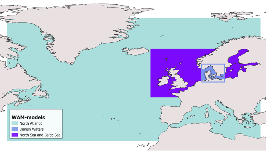
Model Areas
WAM has three geographical areas:
- North Atlantic Ocean (wam_natlant)
- North Sea-Baltic Sea (wam_nsb)
- Danish Waters (wam_dw).
The areas are linked together where they receive wave energy from each other.
Model Area - North Atlantic Sea
The resolution of the North Atlantic model area is relatively coarse (25 km) as data is primarily used to generate boundary data for the North Sea-Baltic Sea area. This means that the coastal line is grossly approximated as is the sea depth. Currently there are no plans of improving the resolution of this model area.
The model is off-shore as breaking of waves in shallow waters is not included (contrary to the two other models). This leads to a an overestimation of near costal waves.
The model has open boundaries. Near these the wave height is typically underestimated due to lack of extraneous swells. The sea along the boundary is estimated to be fully developed (overestimation) with a fetch of 30 km (probable underestimation)
The model includes sea ice which is defined once for each runcycle and applies to the entire forecast length (5½ days). When the ice is dense (>30%) there are no waves even if the area should become ice-free during the forecast and vice versa - ice-free areas that freeze up during the forecast is regarded as ice-free by the model.


