Klimaatlas
Klimaatlas is developed by the National Centre for Climate Research and contains data about expected future changes in the climate at the level of local authorities in Denmark.
DMI's Klimaatlas
DMI has developed a nationwide Klimaatlas (Climate Atlas) based on in-house data, data from the IPCC and various international databases. Data is freely available at this website (in Danish).
The Danish Klimaatlas provides data on municipality, drainage basin and coastal stretch levels showing future changes in temperature, precipitation, extreme precipitation, relative sea level and storm surge heights. It thereby gives an indication of areas with a particular future risk of being impacted by extremes. The tool provides fundamental climate data so municipalities can take the necessary precautions and guard citizens, infrastructure and buildings against the expected extreme weather in the future.
In Denmark, the municipalities are responsible for climate adaptation, for example, securing exposed areas from cloudbursts. The Danish Klimaatlas therefore has the municipalities and their climate adaptation as its primary focus, but it is also relevant for the regions, utility companies, infrastructure, agriculture, emergency management, insurance, consultants and many other sectors. Klimaatlas is thus developed in a valuable collaboration with the municipalities and other relevant stakeholders working on climate adaptation.
Klimaatlas is an authoritative data set on the projected physical changes in weather and climate, e.g. precipitation until it hits the ground and sea water until it hits the coast. But it does not directly address the subsequent fate of surface water, which means that there is no direct information on where flooding will occur, water levels in lakes and streams, ground water levels or coastal erosion. The data in Klimaatlas should therefore be combined with local knowledge on ground water levels, sewers, dikes etc. to complete the full impact analyses of the changing climate conditions. The municipalities can thereby use this nationwide tool in their planning of climate change adaptation measures and in their dialogue with utility companies and consultants.
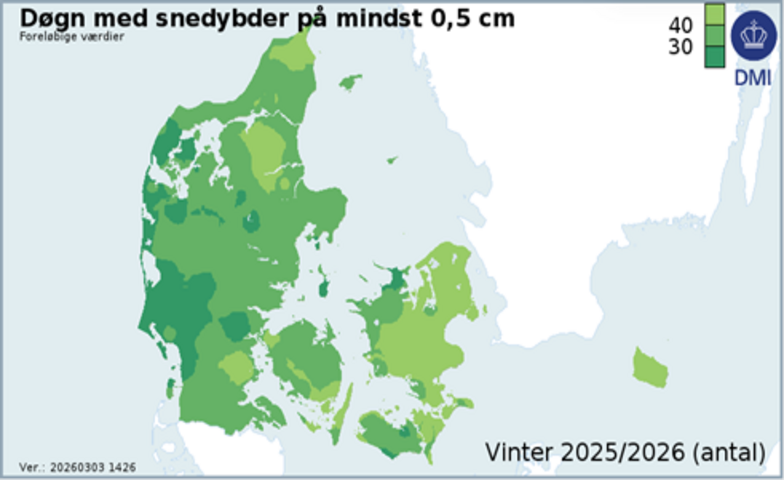
Data in Klimaatlas shows the future Danish climate in the beginning, middle and end of the century for two different greenhouse gas emission scenarios. Klimaatlas shows data on future temperature, precipitation, sea level, wind, evaporation, insolation, storm surges and various specific climate indices both at national and municipality levels – and down to a 1 km grid scale.
Klimaatlas is currently only available in Danish - however, most online machine translation tools give useable results. The follow menu provides links to the key content:
- Retrieve data and products
- Documentation og publications
- Examples of how Klimaatlas is used
- Educational material
If you want to give feedback, report errors or need further explanation in English please follow the link “kontakt”